For the GPX file, please contact: foretultra@gmail.com
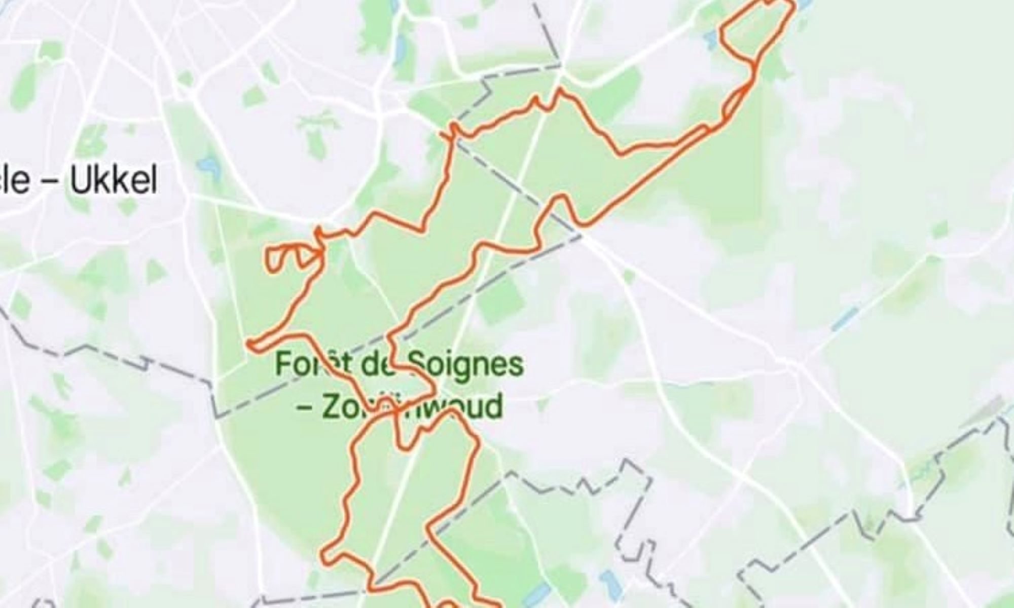
The route contains four sections:
1. Groenendaal-La Hulpe-Groenendaal section (16.5 km)
2. Groenendaal- Tervuren section (16 km)
3. Tervuren Park – Rouge Cloitre/ADEPS – Parc Tournay-Solvay/Tournay-Solvaypark section (19 km)
4. Parc Tournay-Solvay/Tournay-Solvaypark – Groenendaal Abbey section (11.5 km)
| Starting | Arriving | Section (km) | Total (km) |
| Groenendael Abbey – engraving/abbey church | Royal Lodge | 1.34 | 1.34 |
| Royal Lodge | La Hulpe castle gate | 4.22 | 5.56 |
| La Hulpe Castle- Langestaartdreef gate | Castle gate on Kapuzinerweeg | 3.14 | 8.70 |
| Castle gate on Kapuzinerweeg | R0 tunnel-crossing | 2.80 | 11.50 |
| R0 tunnel-crossing | Schone-Eikweg junction | 1 | 12.5 |
| Schone-Eikweg junction | Groenendael Abbey – engraving/abbey church | 4 | 16.5 |
| Groenendael Abbey – engraving/abbey church | Lienard, The Oak | 3,5 | 18 |
| Lienard, The Oak | Capuzijnenpoort ,Tervuren park | 12,5 | 28.5 |
| Tervuren park | Tervuren park | 5 | 32.5 |
| Tervuren park | Arboretum entrance | 2,4 | 34.9 |
| Arboretum entrance | Sharp left before R0 parking | 3 | 37.9 |
| Sharp left before R0 parking | Rouge Cloitre/ADEPS | 3,7 | 42 |
| ADEPS | Delhaize | 3,8 | 46 |
| Delhaize | Memorial | 3,8 | 49 |
| Memorial | Vuilbeekpad | 2 | 52 |
| Vuilbeekpad | Chemin du Hangar | 2,5 | 55 |
| Chemin du Hangar | Groenendaal Abbey | 4,5 | 58 |
Groenendaal-La Hulpe-Groenendaal section (16.5 km)
Start from the metal engraving with the plan of Groenendaal abbey outside of the parking lot of Groenendael Castle. The metal sheet with the engraving (temporarily removed for renovation) is placed on a concrete stand at the side of the former abbey church, under a lime tree. Next you cross the parking lot and the field and head to the first lake (Putselvijver). You follow the path along the shore until it meets Kloosterweg and you reach Saint Cornelius chapel on the right. Here you take a left on Lange Staartdreef, which following a slight elevation meets Hakenstakendreef. When reaching a junction, you continue straight and following a short, steep climb you reach the field of the old hippodrome. You follow the paved road, pass the wildlife crossing (Ecoduct) marked by a carved statue of two otters to the right (at the edge of the grazing field for Scottish highland cattle, with some luck you might spot them) and a wildlife observation tower to the left. (Before reaching the tower, you keep an eye for the cherry trees on the left with and abundance of sweet wild cherries in late June and July. Behind the cherry trees you find a field of raspberry and mulberry shrubs bringing their fruits from late July, early August)). Follow the road and soon enough, you will pass the royal lodge (hyperlink) on the left and the remains of the bookmakers’ stand to the right, partly overgrown by vegetation. Take a sharp right turn (Hakenstakendreef) and descent to enter the tunnel under R0. Emerging from the runnel, take a left to stay on Hakenstakendreef (bicycle path) and follow the path until the first bicycle path branching off to the right a few meters before Terhulpsesteenweg. You follow the bicycle path until it meets Koudedellsweg, where you switch road. A few meters further, Koudedellsweg is crossed by Wildeduisweg, here you keep your general direction by taking Wildeduisweg for xxx meters. You will take a left, at the T crossing and continue on Langestraatdeerf toward La Hulpe castle. This path will lead you directly to the gate to the Castle grounds, and when you cross the gate (and by doing so enter Wallonia, signified by changing the language of the road marks from Flemish to French), the name of the path will change to Chemin de la Longue Queue. You pass by the rhododendron shrubs on the right and some grazing fields on the left. When the castle ahead gets into sight, you have two options:
- Either you continue on the road straight, pass by the field with horses (“poneys des Rênes de la Vie”: therapeutic horses to help special need children) and run around the castle from the left-hand side. Once behind the castle you pass the terrace and the rose-garden. You leave the French garden through a narrow path passing the fountain with the marmaid on your left. Once on the paved road, you bear left until you find the signs for Fondation Folon.
- Alternatively, you leave the paved road and follow a footpath into the woods, cross a mossy bridge arching over a dried, fern-filled stream bed When you leave the words behind, take a turn and cross the grassy field and run toward the castle and away from the obelisk with a golden sun on its top. You take the paved road to the right when you arrive to a white statue at the top of the hill and rejoin the the main route behind the rose garden and run until you find the signs toward Fondation Folon.
You bear right and keep following the signs until you reach the courtyard of the Folon Museum (hyperlink with opening times). You leave the courtyard through the main gate to arrive to the lake shore with a wooden deck for bird watching. You run along the lake on Clos de Campanules switching it to a narrow footpath on the right and keeping as close to the shore as possible. At the far end of the lake you cut through the trees, cross a gravel road slightly to the right and continue in the same direction (away from the lake). You continue amongst tall pines and birches until you reach the gates. You cross the gate, follow the path until it merges with the paved Dreve Josephine. Follow it for a few hundred meters and then take a left to start ascending on Dreve de la Sapinere (good section for deer spotting). From here, you continue until you reach a junction of six roads/paths, where you take a sharp turn and take the first path on your right, which you follow until you see on your left the tunnel under R0. You enter the tunnel and will arrive to Sint-Corneliusdreef (Flemish part of the Forest again with Flemish signs). Take a right before the barrier and after a few steps you will arrive to the junction with Wilderijmweg, where you turn left. You run (in the “gothic cathedral” of the birch forest) until this road ends in a T-junction, where you turn left on to Puntgeveldreef. You leave this road for Dreve Lorraine/Lorreindreef to the right. A few hundred meters later you will take a right onto Schone Eikweg. You stay on this path, which runs along a stream, (dry, most of the year) until it crosses Verdunningsdreef. You cross this path then a barrier for cyclists and continue following the stream on Palissadepad first and then Pneumontpad/Senter Pneumont to the right. The junction of these two paths is marked with a small picnic area and a few explanatory boards about the forest. You continue along the winding stream bed until the first lake comes into your view. You pass all three lakes along their left banks without leaving the stream or the path. You will soon reach St. Cornelius chapel again, continue straight onto Kloosterweg and take a first slight left to stay at the lakeside for cutting through the grassy field in front of Groenendaal castle and reach the parking lot. If you left your car here, you can stop for food and drink, otherwise you leave the parking lot through the gate and cross the gravel road to the starting point.
Groenendaal- Tervuren section (16 km)
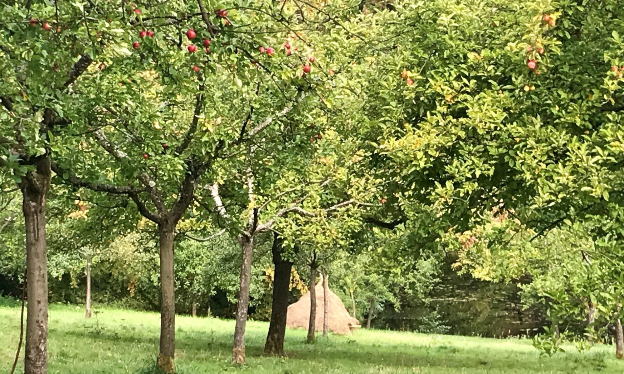
Once you have completed the check-in, you need to head toward the Abbey church, pass the barrier and continue on the gravel road long the lake (Emperor Charles V Pond) shore. You will pass two boards with information on the history of Groenendaal monastery and its funder, John of Ruusbroec, run along the pond leaving it only in its far-left corner when you cross Duboislaan. Pass the carpark on your left on the paved Tumuliweg, until you reach the point where it crosses Sint-Corneliusdreef. Here you take a right, follow Sint-Corneliusdreef until it turns into a narrow footpath, here you turn to the left and run parallel to N275. Reaching Dreve des Bonniers/Bunderdreef you take a right, pass the apple orchard on the left with optional goats, the forest authorities’ house on the right with an explicit white statue in its garden, cross N275, pass the barrier and continue on Dreve Hendrickx/Hendrickxdreef for about 200m and then take a slight left onto Dreve du Comte de Flandre/Graaf van Vlaanderendreef. At the junction you take second footpath to the right, Sentier du Vallon des Chènes/Eikendalvoetpad, and follow it under the birch trees until you arrive to Lienard, The Oak (named after Ulysse Lienard, principal engineer of the water and forest administration between 1960-1976). You continue on this footpath, cross Drève de Bonne-Odeur/Willeriekendreef and soon the path will be join and then run parallel with a most of the year dry streambed. You leave the path and the stream to follow Drève des Mésanges/Mezendreef and then Drève du Tambour/Tamboerdreef, two times to the right. You pass the tunnel and take Petite Drève des Mésanges/Mezendreeftje on the left for a short while before leaving it to follow Drève du Prince/Prinsendreef to the right. Soon you reach Drève des Charmes/Haagbeukendreef, where you turn right for a xxx meters. Just before arriving to the junction with Bosuildreef, you take a small footpath to the left and follow it until it meets Kapucijnendreef. You take a left onto Kapucijnendreef and you follow it all the way until it becomes Isabelledreef and then you keep on until you reach the brick walls of Tervuren-park, which you enter through Capucijnenpoort (Capuchins’ gate). The parking lot outside the walls is normally empty and thus could serve as a good place for a “tailgate” support station.
Tervuren Park – Rouge Cloitre/ADEPS – Parc Tournay-Solvay/Tournay-Solvaypark section (19 km)
Tervuren Park loop will be a 4 km long run in the wonderland of lakes. You enter the park through the Capuchins’ gate and follow Grotenvaartdreef on the right side of the “first” lake under the shadows of a magnificent platanus archade. Turn to the left after the “second” lake at Mathieuweg conjunction continuing on the bank of the “third” lake Perkbosdreef. After passing the “fourth” lake you turn to the left and now you run parallel to Vossemvijver, the biggest and “fifth” lake. From here the view is scenic over the lake. You pass by the Spanish House (Het Spaanse Huis) and if you are lucky or run this section on a Sunday afternoon, you can have a quick refreshment here. You turn to the right on the Spaanshuisdreef and cross the two lakes Gordaalvijver and Vossemvijver. Reaching the other side of the lake you turn left on the Keizerindreef and run until you see on your right the Africa Museum. Here you turn to the left to cross again two lakes or rather a canal and a lake on a traverse and turn to the right on the Spaanshuisdreef. Say farewell to the lakes and turn left on the Bloemenperkdreef. Reaching another car parking spot at the end of this path you follow slightly on your left Torendreef, then turn to your right on Kleine Vaartdreef, then after a few meters turn left – once again to say goodbye to the lakes – and leave the park through Capuchins’ gate.
You cross the Duisburgsesteenweeg and continue your run on the bicycle road on your right, heading into the Sonian Forest. Reaching the Koninklijke Wandeling you turn to the left enjoying a relaxing short “downhill”. Turning to the right you are again on the Kapucijnendreef but after few meters you turn right to Dreefnbergstraat. Here you spend only a few meters then turn to the left to Reeweg. Attention, this is the very first possibility, easy to miss this small path. After reaching the Droge Vijverdreef, which you simply cross by turning to the right and then to the left, where you enter the Tervuren Arboretum. Again, this is a small path not even on the map! But don’t worry, you will shortly reach the Arboretumwandeling, which will guide you through the spectacular collection of trees and herbs. After reaching Tervuren Arboretum car parking, you cross Vlaktedreef and turn to the right to Ravensteindreef. After a while you slightly turn left to an unnamed smaller path, which is almost parallel to Ravensteindreef which will take a really sharp left turn. Attention if you have reached the Tervuren parking next to the R0, then I’m sorry, but you are at the wrong spot. Turn back and take the very first small path to your right. This path is parallel to the R0 and leads you to a small pond where you follow Kleineflossendelleweg crossing underneath R0. The name of the path on other side of the highway called Bezemboomweg. Continue on this path then turn left to Graafdreef, then keep right towards Vijversweg, which lead you to the lakes of Rouge Cloitre. Here you can enjoy the amazing and vivid bird life of the Red Monastery. Leaving behind the lakes and the monastery you cross the E411 highway underneath through a parking spot and turn to the right where in 200 meters you reach ADEPS. This is the main refreshment point, so take your time to fill up your flasks.
After having your well-deserved cheese cake and lait russe you leave ADEPS and turn right into the forest on Sentier des Pins/Pijnenvoetpad. This is a marvellous path runs parallel to a steam usually dried out. Crossing Chemin de Diependelle/Diependelleweg you keep continue on the “Pine path” until you reach Dreve de Tambour/Tamboerdreef. Turn right and basically follow this route until you run out of the forest. Here you start a short city-trail by turning to the left on Rue de Buis/Buksboomstraat, passing the Watermael-Boitsfort cemetery you turn to the right on Chaussée de la Hulpe/Terhulpsesteenweg where you will find another oasis Proxy Delhaize, which is the very last opportunity to get water or other refreshments. Continuing further you turn to the left and cross Avenue de la Foersterie/Vrosterielaan and continue on Chemin des Silex/Vuursteenweeg passing the lakes of Boitsfort. You keep to the left and enter the magical Tournay Solvay Park.
Parc Tournay-Solvay/Tournay-Solvaypark – Groenendaal Abbey section (11.5 km)
It is arguably one of the most beautiful parks in Brussels, which you enter through its East gate (the park closes at 7pm, try to arrive to this point before this time). You take a left and start an ascend until you pass the ruined castle to the left, where you take a right turn and run towards an administrative building on the right. You pass the building and a 10 meters before the large stone stature of a human head called ‘Olmec’ (not visible because of the shrubs during the summer months), you turn left and enter the rose garden (it is perfectly fine to feel immense happiness and life satisfaction when crossing the rose garden). You make a semi-circle and leave the garden through the gate on the opposite end, keep right on the footpath. At the junction, you make a sharp left and start descending toward the castle, until you reach a narrow path to the right leading over a wrought-iron bridge. You cross the bridge, take a look at the lake of the castle park, follow the path until you can take a right before reaching the orchard, pass a young girl’s statue (in memory of Kelda Spangenberg, who enjoyed passing time at the Parc) and enter the walled kitchen garden. Here you pass through the pear tree alley and by the pond with goldfish and waterlilies until you leave behind the park through the south gate. (If you arrive at a time, when the park is closed, you take a left at the east-gate, follow the brick-wall for a sharp uphill and join the route again at this point). Take a right, start running uphill, cross the foot tunnel below the railroad and take the first possible right to cross some field between mulberry bushes (fruiting from late July). You leave behind the fields and re-enter the forest following a footpath on the right after crossing a most-of-the-year dry brook menacingly called “Drowned Children” (Verdronken Kinderenbeek/Enfants Noyès). The path will take you a lake, where you keep to the left and soon you will cross a barrier to arrive to the paved Drève Tumuli, one of the major forest roads. You turn to the right, descend a few meters until you reach the lakes and a wooden bridge to your left. Do not cross the bridge but carry on and take the first footpath to your left, keeping close to the lake shore. You continue following the path at the far-end of the lake, under the birch trees. You cross the brook and after crossing two wooden barriers, take the second gravel road to your left (Drève de l’Infante/Infantedreef). In a few hundred meters, after a slight ascent, you will arrive to the Brussels Memorial 22/03 on your right. (A natural clearing in the birch forest on top of this hill where 32 trees had been planted in the memory of the 32 victims of the 2016 terror attacks at the Brussels airport and Maalbeek metro station.) From here, you have a short downhill, then keep to the left and immediately to the right to descend to the brook. You pass a wooden barrier to your left and head back along the brook toward the lake and a picnic area between the pond and Drève Tumuli. Here you turn to the right and start meandering uphill on Drève Tumuli for a few hundred meters until it meets Chemin des Deux Montagnes/Twee Bergenweeg. Keep an eye out on the two Neolithic tumuli (burial mounds at the junction) This is the junction, in a clearing to the right (take note of the two Neolithic burial mounds (“tumuli”) on the clearing to your right just before you turn to left and pass the picnic table on your right. You run straight until you reach again the railway crossing. The road leads between mulberry bushes on both sides. Before the tunnel, you take a left and start your descent on a footpath (Vuylbeek), following a brook (Vuylbeek) connecting and feeding a string of ponds without leaving this path until it comes to an end. (The path will cross both Drève Tumuli and Drève de l’Infante/Infantedreef). The path will join Chemin du Hangar/Hangarweg, here you cross the wooden barrier and take a left until you arrive to Dreve du Haras/Harasdreef, a busy motor road. Without crossing the road, here you take a left, continue descending and re-enter the forest at the first possibility on Drève Saint-Hubert/Sint-Hubertusdreef to the left. You stay on this road until it meets Chemin du Pivert/Groene spechtweg, where you take a slight right and switch roads. Take another right at the first possibility to Drève l’Infante/Infantedreef. You stay on this road for a longer section and it will run parallel with the motor-road (Dreve du Haras/Harasdreef). You are now very close to the finish: you will take a left to Sint Corneliusdreef, which you leave shortly for the first path on your right (Vleressenpad). This path will lead you to Langestaartdreef, where you take a left and enter a descending road leading between the cc. 1m high wall of exposed birch tree-roots. You cross the motorway, follow the path between the two lakes, take a left to Klosterweg and run along the lake shore toward the Groenendaal carpark. You cross the carpark and continue until you arrive back to the starting point, where you must stop the clock and save the GPX file of your run, so that we can add your name to the finishers’ list. Congratulation, you are now finisher of the Fôret Ultra-60km, hope that you have had a good time running/walking it.